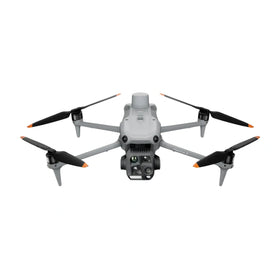
DJI Brings Advanced Mapping Data Training to Europe's Benelux Region
DJI is expanding its Advanced GEO Products Training Services to Europe's Benelux region, targeting the gap between flying mapping drones and producing reliable survey-grade data. The move signals growing demand for operator skills that directly affect commercial drone value and fleet productivity.

Quick answer
DJI has expanded its Advanced GEO Products Training Services programme to Europe's Benelux region, according to DroneDJ, to help operators produce consistently accurate survey data from mapping drones.
- The training targets the gap between basic flight skills and reliable survey-grade data output
- The programme has now reached the Benelux region of Europe
- DroneDJ reports that flying a mapping drone is easy, but getting accurate usable data is harder
- The move reflects rising commercial demand for verifiable mapping and survey capabilities
Evidence: DroneDJ
DJI buying context
Match product news to hardware you can actually deploy.
Check inspected DJI aircraft, repair support, and trade-in timing before deciding whether to upgrade, repair, or wait.

Flying a mapping drone is relatively easy. Getting consistently accurate, usable survey data out of it is a different story. That gap is what DJI is trying to address with its new Advanced GEO Products Training Services programme, which has now reached Europe's Benelux region, according to a report published by DroneDJ on October 6, 2026.
The development matters because commercial drone value is shifting from hardware alone toward the quality of the data an operator can reliably deliver. For fleet managers, survey contractors, and independent pilots running DJI mapping platforms, the ability to produce repeatable, defensible survey outputs is increasingly the difference between winning repeat work and losing contracts to better-trained competitors.
What the training programme addresses
DroneDJ's reporting frames the core problem clearly: many operators can launch a mapping mission, but fewer can consistently turn raw captures into survey-grade deliverables that clients can trust. The Advanced GEO Products Training Services programme is positioned as a direct response to that skills gap, with a focus on the workflow and data-processing knowledge required for professional geospatial outputs rather than basic flight instruction.
For commercial operators, this distinction is significant. A drone that captures images is a tool; a drone workflow that produces verifiable orthomosaics, elevation models, and survey data is a revenue stream. Training that closes the gap between those two states can reduce rework, cut field time, and lower the cost per deliverable across a fleet.
Why the Benelux expansion signals broader demand
The programme's arrival in the Benelux region suggests DJI sees sustained demand for advanced mapping skills among European commercial operators. The Benelux market includes dense infrastructure, active construction and agriculture sectors, and a strong surveying tradition, all of which depend on precise spatial data.
Reboot Hub analysis: the expansion is consistent with a broader commercial trend in which enterprise drone procurement is increasingly tied to data outcomes rather than aircraft specifications alone. Buyers evaluating mapping platforms should weigh the availability of structured training and workflow support as part of the total cost of ownership, not as an optional add-on.
What this means for drone owners and the market
For current DJI mapping drone owners, the training expansion is a signal that data competency is becoming a formal part of the commercial ecosystem. Operators who invest in structured training may be better positioned to bid on projects that require documented workflows or quality-controlled outputs. Conversely, those who rely on informal learning may face rising expectations from clients who now understand the difference between a flight log and a defensible survey deliverable.
The pre-owned DJI market is also affected. As commercial buyers increasingly evaluate drones based on their role in a data pipeline rather than their airframe alone, the resale value of mapping platforms may become more closely tied to the operator's documented workflow and training history. A well-maintained mapping drone paired with a trained operator represents a more complete commercial package than hardware alone. For operators considering pre-owned DJI drones, the relevant question is not only whether the airframe is sound, but whether the workflow and skills around it can produce client-ready data. Those evaluating the economics of professional drone ownership can consult the Drone Wiki for repair and ownership context that supports long-term fleet planning. For owners evaluating service and lifecycle risk, Drone Wiki explains the relevant repair, parts, resale, or operational path.
Reboot Hub analysis: For repair customers and fleet managers, the training news reinforces the importance of sensor and payload health. Mapping accuracy depends on calibrated cameras, stable gimbals, and clean data capture. A drone that flies perfectly but has a misaligned sensor or degraded lens can silently compromise survey outputs. Operators who understand data quality are more likely to detect those issues early and seek professional DJI repair or genuine OEM spare parts before a deliverable fails client review.
The commercial case for data-first drone planning
DroneDJ's report does not provide pricing, curriculum details, or certification specifics for the Benelux rollout, so operators should treat those details as unconfirmed until DJI publishes official programme information. What is clear from the source is that DJI is investing in structured training as a complement to its mapping hardware, and that the company is expanding that investment into new European markets.
For procurement teams, the practical takeaway is to evaluate mapping drone purchases as part of a larger data workflow. The aircraft, the sensor, the processing software, the operator's training, and the maintenance plan all contribute to whether a mapping programme produces usable survey data. A fleet built around the cheapest airframe but without data discipline may cost more in rework and lost bids than a slightly higher upfront investment paired with structured training and reliable repair support.
For independent pilots, the message is simpler: the market is starting to distinguish between drone operators and geospatial data providers. Training programmes like the one DJI is expanding into the Benelux region are one route toward the latter category. The operators who close the data gap early will likely have an advantage as commercial clients tighten their requirements for accuracy, repeatability, and documentation.
FAQ
Frequently asked questions
What is DJI's Advanced GEO Products Training Services programme?
According to DroneDJ, it is a DJI training initiative designed to help mapping drone operators move beyond basic flight skills and produce consistently accurate, usable survey data for commercial and geospatial applications.
Where has DJI expanded this training programme?
The programme has now reached Europe's Benelux region, following its earlier availability in other markets, as reported by DroneDJ on October 6, 2026.
Why does mapping drone training matter for commercial operators?
Flying a mapping drone is relatively easy, but producing reliable survey-grade deliverables requires workflow and data-processing knowledge. Training that closes this gap can reduce rework, improve client outcomes, and strengthen an operator's competitive position.
Which sources support this update?
The visible evidence links identify DroneDJ; each source is used only for the claim it directly supports.
What remains subject to change?
Retail pricing, availability, product bundles and regulatory timelines can change. Readers should verify the latest terms with the named retailer, manufacturer or regulator before acting.
How should buyers or operators use this analysis?
Use the verified facts as a starting point, then compare mission fit, lifecycle support, maintenance needs and current procurement terms before making a purchase or fleet decision.
Surse consultate
- DroneDJ - primary source
La momentul publicării, nu era disponibilă documentație oficială suplimentară.
Redacția Reboot Hub oferă analize privind achiziția, reparația, revânzarea și operarea pentru proprietarii de drone. Dacă observați o eroare, contactați-ne pentru revizuirea corecției conform politicii noastre editoriale.